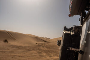
Morocco
Driving through the Sahara desert
Is it difficult to drive through the sahara desert? For us as amateur novice overlanders it was challenging but not difficult. In October 2022 we
We travelled 17 days with a 4×4 through the land of fire and ice. This was in August 2021. In total we covered 2456 km. We started in Reykjavik in went clockwise around the island. Trying as many greenlaning routes in Iceland as we could, avoid mass tourism and hike as much as possible.
Day 1 Amsterdam – Fagradalsfjall volcano
Day 2 Fagradalsfjall volcano – Reykjavik – snaefellsnes peninsula
Day 3 snaefellsnes peninsula – raudisandur (Westfjords)
Day 4 raudisandur (Westfjords) – Holmavik
Day 5 Holmavik – Hveravellir
Day 6 Kerlingerfjoll – Akureyri
Day 7 Akureyri – Husavik
Day 8 Husavik
Day 9 Husavik – Möðrudal
Day 10 Möðrudal – Egilsstadir
Day 11 Egilsstadir – Vestrahorn
Day 12 Vestrahorn – Kirkjubæjarklaustur
Day 13 Kirkjubæjarklaustur – Landmannalaugar
Day 14 Landmannalaugar – Thagil
Day 15 Þakgil – Husavik
Day 16 Glymur – Vik
Day 17 Vik – Reykjavik – Amsterdam
Amsterdam – Fagradalsfjall volcano
– August 2021 –
Well… there we finally went, travelling in COVID style. We already planned to go one year earlier but that was cancelled due to new restrictions.
We arrived at Schiphol Airport around 3 p.m. and we boarded our airplane 2 hours later. We exchanged euros for Icelandic króna at the airport, however after arriving in Iceland we soon noticed you can pay by pin (contactless) everywhere.
It took ages before we took off. Somebody forgot their PCR test but the airline company already boarded their luggage. After an hour delay and a 3 hour flight we finally arrived!
We pre-booked our 4×4 Subaru Forester at KUKU campers and they arranged our pick-up from the airport. The Subaru was an excellent car. The back seats were replaced by a mattress so you could sleep in the car. And everything else we rented for camping was waiting for us in the car; camping chairs, cutlery, plates, sleeping bags etc.
TIP Our first tip: GET A 4×4 vehicle
First we stopped at a supermarket to have some basic supplies. Oeefff, groceries in Iceland are expensive!
We had one important bucket list destination in Iceland and that was the Active Vulcano. Weeks before we left we did a lot of research to try and figure out how the monitor the activity of the volcano (read more).
We searched for a campsite near the volcano because we knew there was a chance the volcano could be really active the next day.
Wow! We were so lucky to see the volcano so active! Read this blog for a more detailed guide of the volcano.
We didn’t expect to stay for lunch but ended up spending more than 7 hours at the eruption site. After getting back to our car we drove straight to Reykjavik. Checked out the city center and more importantly found a place for late lunch. We are no city people, therefore we continued our trip up north after a good fish soup.
TIP We definitely recommend Salka Valka for lunch.
Next up: the Snæfellsnes peninsula. Because we were so exhausted we searched for a nice campsite, set up camp, made some risotto and went to sleep.
TIP We stayed at Hellissandur Camping. In the end this campsite was one of the nicer ones during our trip. Clean and modern facilities.
Fagradalsfjall volcano – Snæfellsnes peninsula
Highlights:
– Fagradalsfjall Volcano
– Reykjavik
Snæfellsnes peninsula – Rauðasandur Beach
Highlights:
– Kirkjufell
– Rauðasandur
So after packing up the car we stopped at a small bakery to get a coffee and drove to the first highlight of the day: Kirkjufell. This iconic mountain has a breathtaking view which can be seen when you are standing in front of the waterfall. There is a small parking lot, you cannot miss it. It’s a 5 min walk from the parking to the viewpoint. It’s beautiful, but you will not spend hours there. Drones are not allowed because it’s private property.
We continued our journey deeper into the Westfjords. We found a campsite on the Rauðasandur Beach. And damn this place is pretty. You might get the feeling you could get attacked by a Viking every moment. TIP Pro tip: play some Vikings music during driving for more epicness. Our 4×4 was getting more useful because roads were getting more serious. Still all doable but we are guessing not so fun in a Kia Picanto or Toyota Aygo. Along the way we stopped a lot to take in the surroundings. Then Google Maps said we arrived at the campsite. We saw some camping spots, but there was no one else. Well, that’s an advantage of the Westfjords. Also… don’t expect fancy facilities on campings in Iceland. It’s all very practical.
It rained a little bit so we took a powernap. In the afternoon we walked on the beautiful beach. The sand is red and there are seals on the beach. You can get quite close to them. The Westfjords is really nice for hiking. So that’s exactly what we planned to do the next day! Oh wait you want to know what we ate? There was a small kitchen at the camping. We made some boring but easy omelets 🙂
We woke up early in the morning. The weather forecast was really shit, so we decided to leave a day earlier to our next highlight: puffins! From the campsite to Latrabjarg, it was a 1 hour, beautiful drive.
It was still raining and really hard. We started hiking in the rain knowing it would be all worth if we saw the first puffin. But when we arrived there where no puffins anymore. So a good tip: check this website to see if they are still in Iceland. We were a day too late. Ah well we had a good shower because of the rain.
We set our navigation to Patreksfjörður. One of the biggest villages in the area to re supply. There are no big supermarkets in this village.
We continued to Dynjadi waterfall. Again the route is one awesome filmset. You will appreciate driving around. This route is not really difficult. It’s all gravel and a bit bumpy but no 4×4 experience needed.
The Dynjadi waterfall is big! You can hike all the way up. Get some nice photos on the upper part. Someone else needs to take it from below. TIP: get the position with your phone first. The lens of your camera will get wet so you need to be fast.
We continued to Holmavik. This is on the other side of the Westfjords. Google Maps gave us two options. We took the longer one as we enjoyed driving around so much and had all the time of the world. This was our first introduction to the F-roads. But not a planned one. F roads are roads only accessibele by 4×4 vehicles. If you see this sign, don’t overestimate yourself in your Kia picanto. We have a full blog on F roads here.
Summary: the F66 is awesome! But you need some 4×4 skills. Check out our photos. We took around 3 hours to complete the route. But did a lot of stopping to take photos, to enjoy and ofcourse to drone.
After we arrived on tarmac again we were both so excited we made it that we treated ourselves with pizza. Great recommendations by the way. We set up camp at the Holmavik community camp. Great place for a short stay. We could see the sea from our spot.
raudisandur (Westfjords) – holmavik
Highlights:
– Puffins
– Dynjadi Waterfall
– Route F66
Holmavik – Hveravellir
Highlights:
– F35 Route
– Geothermal Area Hveravellir
After our breakfast we went to the sports center next to the campsite. We bought a day pass so we could go to the gym and use the shower facilities. There is also a big outdoor swimmingpool if you would like a morning swim.
Again we had some adventures ahead. We were going to the Icelandic highlands: kerlingerfjoll. To get here you need a 4×4 to cross the F35. The first 2 hours are not that difficult. It’s the last part you notice why only 4×4 may pass.
We first stopped at Hveravellir, a geothermal area with a lot of hotsprings. There is a campsite next to the hotsprings so you can jump in after the groups are gone. You can also have dinner at the camp lodge. They have different kind of soups and other Icelandic specialities. There was a lot of wind so we went to bed early so we could leave early for kerlingerfjoll.
We left around 06:00 in the morning when it was still dark. We wanted to avoid the crowd because the next highlight is one of our favorite on our list. Not one of our greatest ideas. The road is filled with rocks and bumps are everywhere. Driving on a 4×4 road is one thing, but driving it in the dark is a lot more difficult. Ah well.. after an hour drive the sun came up and we were about 15 min away from kerlingerfjoll. This national parc is big, we didn’t know there was a campsite that’s why we camped at Hveravellir. But now you know, just skip that one.
The last part is more difficult. A lot of steep and rocky roads. We were so early we couldn’t find the parking lot. You know you are at the right place if you see a big information board with all the hiking trails and a triangle shaped tiny cabin.
So know you think: Good job! First one there, great light because of the morning sun. But no, it was so misty we couldn’t see for more than 5 meters. After 45 minutes waiting in the car and still no other people we thought; let’s just go!
Best decision ever! The hiking trail runs in a circle. Although it was only a 30 min hike it cleared up nicely. We took the longest trail and it was awesome. I think you can hike here for days and not get bored. That’s also the reason one of the most famous multiple day hikes The Laugavegur is in this area. Every color is represented. There is boiling water everywhere. It’s one of a kind.
After a few hours of hiking we took the same route back on the f35 to Akureyri. We treated ourselves with a good lunch at Bryggjan in Akureyri. Afterwards we got some groceries and searched for a camping spot at Systragil camping.
Kerlingerfjoll – Akureyri
Highlights:
– Hiking Kerlingerfjoll
Akureyri – Husavik
Highlights:
– Hiking the fjords of Akureyri
– Geosea thermal pool
We didn’t had anything planned for this morning. We asked the owner of the campsite if there are any nice hiking trails nearby. He advised us to go to the other side of the river, which was a 5 minute walk from Systragil camping.
When you cross the bridge you see a parking lot. Here is a big information board with all the hiking routes. If you have a good fitness level we recommend you to hike up all the way to the top of the fjord. It’s around 1.5 hours and the views are spectacular.
After this we drove to Husavik, the whale capital of the world. We reserved a spot at Geosea. A thermal pool with a fantastic view. Some people even see whales swimming by.
We arrived a little early at Husavik so we explored the town for a little bit. The weather was beautiful and it felt like a Mediterranean summer. We sat on the terrace of Salka restaurant for about an hour. Husavik has an own brewery Húsavík öl. They have a lot of special beers. We especially loved the red fruit beer.
After some drinks we went to Geosea. It was an awesome experience we preferred the smaller scale compered to blue lagoon. After two hours in the water we ate something at Salka again.
Next, we drove to our next campsite near Godafoss because we wanted to visit the waterfall early the next morning before the masses came. We stayed at Lifsmotun, not the best camping and we got attacked by a million flies but it was one for one night.
We woke up early and had a 30 minute drive to Godafoss. We arrived just after sunrise and were the only ones there.
Godafoss may not be the tallest, or the most famous, but one look at this striking waterfall is all you’ll need to persuade you to visit it.
Goðafoss is widely held to be one of the most spectacular waterfalls in Iceland, and locals have nicknamed it “The Beauty”, in contrast to the neighboring Dettifoss, called “The Beast”.
After walking around for about 20 minutes, we had our breakfast with the amazing view of the waterfall.
So we looked forward for this day for such a long time. This is the day we booked a whale watching tour on a RIB speedboat.
But because the tour started after lunch time we first wanted to explore the area a bit more. Driving a long the coastline was what we found one of the most relaxing things to do. We also had a mission, spotting a whale from the cliffs. It is possible along the northern coast. They swim into the fjords because there is a a lot of food. You could spot and recognize them from blowing water (breaching) which can reach several meters high.
We found a relaxing spot 30 min. drive from the campsite. Sat on the cliff for about an hour. The weather was beautiful. Such an relaxing environment.
After our simple lunch -sandwiches with cheese- we started to head back to Husavik. We booked a RIB tour with Gentle Giants. These fast speedboats can adapt quickly and you have the best chances of seeing whales. It was a fantastic experience! We saw a lot of whales. It was hard to get a good picture because they show up randomly. But because of the amount of whales Husavik proved it is the whale capital of the world!
After all this adrenaline we went to Camping 66North. This was one of the best campings yet. You can setup camp really close to the sea.
We cooked a simple meal in the campings kitchen and enjoyed the sunset.
Husavik
Highlights:
– Godafoss
– Whale watching with a RIB boat
– Driving a long the coastal roads
– Fantastic views camping NORTH
Husavik – Möðrudal
Highlights:
– Detifoss
– Lava fields of Myvatn
– Crater of Mt. Hverfjall
– Camping at Möðrudal
We woke up early again to be one of the first at Dettifoss. If you want to avoid the crowds on the ring roads attractions this is the only way.
We liked Detifoss way more than Godafoss. You can come really close to the waterfall and because the cliff is narrow you get a spectacular view.
We continued to the lava fields of Myvatn we parked our car near the entrance of the park of Dimmuborgir and went for a hike. There are multiple hiking routes. We walked all the way up to the top of the crater Mt. Hverfjall. It has some nice views but was not really spectaculair. Sometimes while traveling you just have a day that is less spectaculair. We did so much awesome things closely after each other that today was such a day.
But Because we didn’t really had a follow up plan we searched for some nice campings to call it a day. We found a gem of a camping near Möðrudal, sometimes your mood can change quickly!
It was called Campground Möðrudal, it is situated in an old village. There is an awesome restaurant on the campsite and the area gives you a lord of the rings feeling.
We prepared some lunch on the campground, they have a really cool kitchen area.
After some relaxing we had dinner in the restaurant. It was one of the best meals we had in Iceland. Especially the dessert, homemade Icelandic skyr was so good!
So instagram made us really excited for one hotspot. The Stuðlagil Canyon. People make photos here like they are in a Game of Thrones scene.
It was an hour drive from the camping to the canyon. Information about the parking was confusing. You park at the other side of the cliff. It used to be a one hour hike from the parking spot to the canyon because couldn’t cross the bridge and the land was on private property so no cars where allowed.
So, as good tourist we thought to obey the rules and park the car at the first carpark and hike up.
Well for your information. You can cross the bridge now there is a parking at the end of the road. From the parking lot its a 20 minute walk.
The Canyon for us was a bit disappointing. The water level was really high when we were there. Still beautiful place but small.
After an hour at the canyon we booked a spot at a thermal bath called Vok Baths. We stopped at a bakery for some local pastries before going to Vok. The baths cross over a lake so you can switch from the hot bath to the cold lake. It’s a nice thermal bath, only negative thing was there were a lot of children jumping into the water. Pretty annoying for all the guests who came there to relax.
From Vök Baths we went for a drive to the village of Seyðisfjörður. This is a beautiful drive through the mountains. The village is very nice with al its colors and the small church. Its a little touristy but still very nice. We had coffee and cake at Nordic Restaurant.
We returned to Egilsstadir around dinner time and ate pizza at askur pizzeria. You can build your own pizza and they have great beers!
Because we were still not tired and were nearby Hengifoss, we thought; just do it.
Hengifoss is beautiful! Its the third highest waterfall in Iceland, 128 meters. From the parking place its about an hour walk. Because we were so late there was literally no one else.
We searched for a camping nearby because it was already getting dark. We set up camp at Hengifoss Guesthouse. Not anything special but the facilities were good.
Möðrudal – Egilsstadir
Highlights:
– Stuðlagil Canyon
– Vök Baths
– village of Seyðisfjörður
– Hengifoss
Egilsstadir – Vestrahorn
Highlights:
– Laugarvalladalur Hot Spring
– Vestrahorn
Because we had quite a preparation for our Iceland trip we found some blog posts about a hot spring in the middle of nowhere. A free, non touristy hot spring.
The hot spring is called Laugarvalladalur you can click here for the coordinates. The special thing about this hotspring is the hot waterfall.
If you have a 4×4 we really recommend going there. This was absolutely the best hot spring we ever had. It’s not big but because its harder to get here and its in the middle of nowhere so most of the time its not busy. You drive the F910, there is a small parking spot. From there it is a 400m walk to the pool.
Because the pool is not monitored don’t just jump in. The temperature can fluctuate. We stayed around for 2 hours and continued our journey to the eastern part of Iceland.
We took the main road 1 to Vestrahorn. Again a spectaculair route. The scenery gets greener and greener and the cliffs get steeper.
We decided to stay in the campsite of Vestrahorn. Its nice you get acces to the park, because you need a ticket to enter and you get one with a camping spot.
But the campsite is not more than a parking space. The spots are tight and it gets really crowded. This was one of our worst camping experiences.
But the hike with sunset on the beach of Vestrahorn made up the bad camping spot.
We didn’t really have a solid plan on this day. We were up early because it was so crowded on the campsite. Getting a shower was a difficult task.
Then we drove to Diamond Beach. This is a black beach, not uncommon in Iceland. But because of the near glacier blocks of ice are carried by the river to the black beach, just looking like diamonds. It’s cool but expect a lot of other tourists.
Because this annoyed us a little bit we started searching for other things to do in the area. We found one of the best hikes we ever did: Mulagljufur Canyon. You can read the full article here. If you like hiking and less tourists. This is epic!
The hike made us hangry so we searched for a nice place to get lunch. We stopped at Cafe Vatnajokull. Definitely recommend! They have really nice sandwiches and paninis and clean bathroom facilities.
After our stop we went to Svinafelljokull glacier. We didn’t do the tour where you go up the glacier, we think this is awesome to do but because of time shortage we decided not to. We just went to Svinafelljokull viewpoint. From this parkingsite it’s about a 10 minute walk. Because of the hot weather when we were there the view was an awesome contrast.
Then we went to Svartifoss waterfall, it is an ok hike, in our opinion not really special and really crowded. Would not recommend it.
After an exhausting day we set up camp at Kirkjubæjarklaustur. Nice camping with good facilities. There is a good restaurant 2 min. walk away. We chose this campsite so we would arrive early at the Fjaðrárgljúfur Canyon the next morning.
Vestrahorn – Kirkjubæjarklaustur
Highlights:
– Diamond Beach
– Mulagljufur Canyon Hike
– Svinafelljokull Glaciar
– Svartifoss Waterfall
Kirkjubæjarklaustur – Landmannalaugar
Highlights:
– Fjaðrárgljúfur Canyon
– F208 to Landmannalaugar
– Bláhnúkur Hike
First to arrive at the Fjaðrárgljúfur Canyon. We were really excited. This canyon was hyped after Justin Bieber filmed a video clip here. It is an awesome location, they made a lookout point because the fauna was getting destroyed by tourists going off the tracks.
It was still early and later we would take route to Landmannalaugar, in the middle of the island. You need a 4×4 again.
Before we left we did some shopping in the mall of Vik. There is a nice coffee shop and supermarket. We needed some supplies because you cannot get any in the middle of the Parc.
We found out that on the route to Landmannalaugar there was a really cool drone location. This was the award winning location of drone photography. You can find it on these GPS coordinates.
As always, the route was phenomenal. We drove a long the F208 and past the Sigoldugljufur canyon. This canyon is absolutely stunning and we defently recommend spending some time here. To reach the campsite in Landmannalaugar you need to cross a river. It depends on the weather conditions how hard it is.
If you are not comfortable with this you can also park your car at the parking area before the river. If you are a unexperienced 4×4 driver, relax and observe. Wait till someone else goes and observe their route. If you are not sure, don’t do it!
There are a lot of epic hiking trails starting from the campsite. Because it was already later on the day we decided to climb the bláhnúkur or the blue mountain. The highest point in the area. Its about a 1.5 hour hike up. Spectaculair views!
Back at the car we had our dinner: an omelet, some sandwiches with Nutella and crisps. Well that’s camping in the wild.
Another day another hike. In the morning we wanted to do another hike in the area. There are so many hikes in this area. Definitely coming back to Landmannalaugar to do the 5 day long… hike.
First we took a shower, don’t expect much from the facility’s here. But it’s oke, the scenery makes up for everything.
So today we decided to do the brennisteinsalda hike. a 2-3 hour hike, not really hard. You walk throng the lava fields and the geothermal area.
The hikes are spectaculair, the F roads are even more spectaculair. The route back to Vik on the F208 was one hell of a ride of epic grasslands, mountains, lava field and river crossings.
We returned to Vik to get lunch again at our favorite restaurant: the soup company. You can get a free refill and the soups are awesome here!
We decided to camp at Thagil (Þakgil), because we heard this was one of the most beautiful campings in Iceland. Not the most efficient route but sometimes you need to do a detour.
It was an hour drive. We had an fantastic spot. The campsite is pretty big and there are good facilities. From the campsite you can do a lot of different hikes. We chilled the rest of the day, did some reading and went to bed.
Landmannalaugar – Thagil
Highlights:
– brennisteinsalda hike
– The Soup Company in Vik
– Camping at Thagil
Þakgil – Geysir
Highlights:
– Reynisfjara Beach (Black Beach)
– Waterfall of Gjain
– Gullfoss
After a relaxing breakfast in awesome scenery we didn’t really have a plan.
We decided to go to black beach or how its really called: Reynisfjara Beach. This is a tourist hotspot. There are a lot of black beaches in Iceland. We don’t understand why everyone goes to this one. So its a nice spot but and the basalt pillars are nice. But wouldn’t recommend staying here for to long.
After this we set a route up west again to the waterfalls of Gjain. This is a lesser known area. There are multiple parking areas with picknick benches where we stopped to eat some snacks and sandwiches. We love going out for lunch but also enjoy our own packed lunches :). We walked around the nature area a bit and hiked up to the waterfalls, there were no other visitors so we had the place to ourselves whereas in the morning the black beach was very crowded with tourists.
After Gjain we got back in the car and drove to Gullfoss. This is one of the major tourist attractions. The weather was not so good it was raining a lot when we arrived so we took a quick look at the waterfall and then spent some time in the gift shop next to it.
Next we drove past Geysir and searched for a campsite. We arrived quite late at the campsite, it was nothing special and no good facilities. We found a spot (it was quite crowded), tucked into our sleeping bags and went to sleep.
We arrived early at Glymur. This is Icelands second highest waterfall. You can only get to it by hiking. But if you like hiking this is a must do.
You need to cross two rivers and walk through caves. You need good shoes and we promise you they will get wet!
If you do the complete hike its about 3/4 hours. You will hike up to the viewpoint of the waterfall. Now you can decide to turn around or complete the track.
You walk further up to the top and cross the river again there. Now you decline and complete the circle.
After we dried up (at the end it started raining pretty hard). We treated ourself on a hot chocolate at cafe Kaja in Akranes. We also did some groceries at Bonus and filled up the tank.
So now our route gets a little bit weird. We saw some pictures of people driving their 4×4 through a waterfall. After a lot of searching online we finally found out where it was.
Turned out we already were nearby when we returned from Landmannalaugar. Because we loved the F-roads we thought: fuck it, we go back to Vik and drive the F- again and go trough the waterfall!
So we had a quick lunch at Englendingavik in Borgarnes and drove back for 3 hours to Vik. Yes we know, weird route.
We set up camp at the Vik Campsite and went to sleep.
Glymur – Vik
Highlights:
– Hiking Glymyr waterfall
Vik – Reykjavik
Highlights:
– Waterfall crossing on the F…
– Sky lagoon
Ok, we have to be honest. We hesitated multiple times if we should do it. I mean it was our last day and we wrote online that the F… is a rough road.
We didn’t know exactly where it was and how long it would take. But we could always turn back if it took to long. We had about 3 hours before we had to head back to Reykjavik.
The F… is awesome! It’s like you landed on the moon. It’s pitch black ground everywhere. On the horizon you see this white enormous glacier. From Vik to the waterfall on the F… is not that hard. You need to cross a few rivers but they where not deep when we where there.
From Vik we took the F209 until we saw a sign with Oldufell F232. After 1 hour on the F232 we finally arrived at the waterfall. We crossed it a few times to get some nice photo’s. We are defiantly coming back to complete this route, because this road goed to Akris?
This is viewed as one of the most hard F roads in Iceland and is also one of the most remote places.
We returned to Reykjavik and had a booking at the newly build geo pool Sky Lagoon. For me this was a little bit disappointing.
It felt a little bit fake and it was really touristy. We where used to the last geothermal pool in the middle of nowhere. But it was a nice way to finish of our Iceland trip!
Is it difficult to drive through the sahara desert? For us as amateur novice overlanders it was challenging but not difficult. In October 2022 we
The ferry from Algeciras to Tanger med In october 2022 we took the ferry from Algeciras to Tanger with our land rover defender. For us
Fuel in Morocco on a 4×4 offroad trip We toured around morocco in our landrover defender in October 2022 for 16 days and this is
© 2024 Lewie and the Rover